Landing information - LOLK
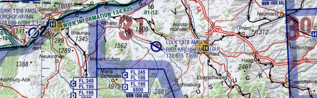
| Coordinates | 48 12 45 N 013 20 42 E |
| Elevation | 1378 ft (420 m) |
| Radio frequency | Kirchheim Radio: 122,65 (ge, en) |
| Runway | 12 (116°) / 30 (296°) |
| Dimensions | 743 x 18 m |
| Surface | Asphalt |
| Tonnage | 5.700 kg |
| Admissible for | engine powered planes, gilder, helicopter |
Approach and departure
- Contact KIRCHHEIM RADIO at least 5 minutes before reaching the place. In aerodrome traffic listening watch needs to be maintained.
- If available, indicate GPS distance to ARP when reporting position (e.g. OECEM, final approach runway 30, 1.5 miles)
- NORDO ACFT: approach from North East
- Look out for training flights and gliders
- The traffic circuit is south-west of the runway.
- In traffic circuit a flight level of 2500 ft MSL needs to be maintained
- Flying across the surrounding villages is to be avoided
- When approaching from the north, look out for traffic in the north-east circuit (traffic pattern for gliders)
Weather
18.07.2025, 22:24 UTC
| Wind: | 070°, 3 ktn |
| Temperature: | 13 °C |
| Dewpoint: | -2 °C |
| QNH: | 1011 hPa |
Opening hours
March - October
Mon - Sat: 10.00am - SS
Sun & Holidays: 09.00am - SS
November - February
PPR
Traffic circuits
To be coordinated with KIRCHHEIM,
but not after 20:00 LT.
Approach chart
Contact tower
Tel: +43 (7755) 64 14
Fax: +43 (7755) 64 14 4
turm@sfc-ried.at
Contact flight operations officer
Josef Maringer
+43 (650) 4204679